


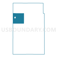
Hendricks Twp. Voting District, Lincoln County, Minnesota
About
Outline

Summary
| Unique Area Identifier | 602932 |
| Name | Hendricks Twp. Voting District |
| County | Lincoln County |
| State | Minnesota |
| Area (square miles) | 36.47 |
| Land Area (square miles) | 35.09 |
| Water Area (square miles) | 1.38 |
| % of Land Area | 96.21 |
| % of Water Area | 3.79 |
| Latitude of the Internal Point | 44.50017550 |
| Longtitude of the Internal Point | -96.38595220 |
Maps

Graphs
Select a template below for downloading or customizing gragh for Hendricks Twp. Voting District, Lincoln County, Minnesota


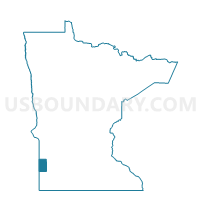
Neighbors
Neighoring Voting District (by Name) Neighboring Voting District on the Map
- Ash Lake Twp. Voting District, Lincoln County, MN
- Hansonville Twp. Voting District, Lincoln County, MN
- Hendricks Voting District, Lincoln County, MN
- Marble Twp. Voting District, Lincoln County, MN
- Royal Twp. Voting District, Lincoln County, MN
- Shaokatan Twp. Voting District, Lincoln County, MN
- VTD-precinct 10, Deuel County, SD
- VTD-precinct 9, Brookings County, SD
Top 10 Neighboring County Subdivision (by Population) Neighboring County Subdivision on the Map
- Hendricks city, Lincoln County, MN (713)
- Scandinavia township, Deuel County, SD (208)
- Hendricks township, Lincoln County, MN (201)
- Lake Hendricks township, Brookings County, SD (189)
- Royal township, Lincoln County, MN (189)
- Shaokatan township, Lincoln County, MN (178)
- Marble township, Lincoln County, MN (161)
- Ash Lake township, Lincoln County, MN (151)
- Hansonville township, Lincoln County, MN (90)
Top 10 Neighboring Place (by Population) Neighboring Place on the Map
Top 10 Neighboring Unified School District (by Population) Neighboring Unified School District on the Map
- Canby Public School District, MN (3,660)
- Deubrook School District 05-6, SD (1,902)
- Ivanhoe Public School District, MN (1,287)
- Hendricks Public School District, MN (1,086)
Top 10 Neighboring State Legislative District Lower Chamber (by Population) Neighboring State Legislative District Lower Chamber on the Map
Top 10 Neighboring State Legislative District Upper Chamber (by Population) Neighboring State Legislative District Upper Chamber on the Map
Top 10 Neighboring 111th Congressional District (by Population) Neighboring 111th Congressional District on the Map
Top 10 Neighboring Census Tract (by Population) Neighboring Census Tract on the Map
- Census Tract 9586, Brookings County, SD (3,746)
- Census Tract 2010.01, Lincoln County, MN (3,095)
- Census Tract 9536, Deuel County, SD (2,924)